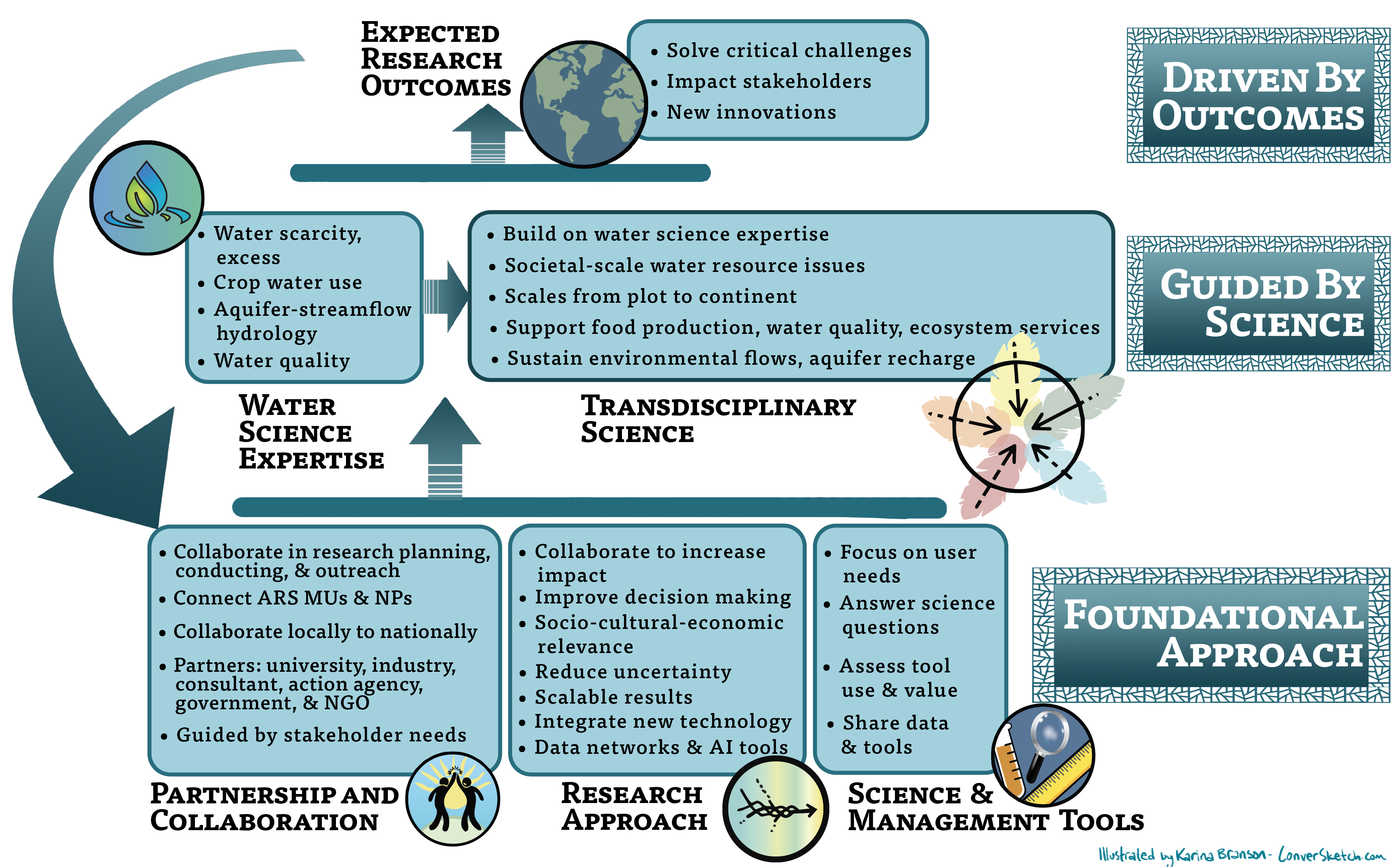
The challenges of today and tomorrow to ensure a plentiful supply of high-quality water for agriculture and the Nation must be addressed with a vision and research agenda that leverages new technologies and integrative approaches. The water vision 2050 research approach is shaped by our history and builds upon our rich research capital.
Perform Multiple Metric Assessment. Agroecosystem decision making does not often involve simple problems. Decisions must consider producers, water and other natural resource managers, and the surrounding communities because outcomes have greater impacts than just at the point of the decision. For instance, minimum waterflow rates for aquatic habits must account for upstream agricultural producers who make decisions on irrigation withdrawals or on the selection of crops that require more or less water. Scientists will develop multiple metrics to assess agroecosystem performance, communicate the interdependencies of these decisions, and coordinate the decision processes from the different sectors. These metrics will weigh the different perspectives and outcomes and will be communicated to the public with both thoroughness and sensitivity.
Integrate and Develop New Technology. New technologies will emerge in diverse domains such as in situ and real time sensors (e.g., soil and plant property sensors, water quality, aerial imagery), bioengineering (e.g., wastewater treatment and reuse), and informatics and computer science (e.g., artificial intelligence and machine learning). With the development of more advanced sensor technologies and telemetry, research methods will rely on greater amounts of measured real-time data at refined spatial and temporal scales. Because the human resources will likely not increase with these needs, ARS scientists will continuously work with industry leaders to develop and to evaluate new monitoring technologies that require less human intervention for equipment calibration, maintenance, and data collection, and processing techniques for data quality analysis and control, ultimately leading to higher-quality, actionable information, and decision support systems. For problems such as waste management and reuse, water treatment, and pesticide and bacteria removal from agricultural runoff, scientists will invest resources toward the development of bioengineering technologies to develop creative solutions.
Artificial intelligence and machine learning techniques will provide new collaboration and research opportunities to solve problems that have remained intractable and to address important system components. These techniques could propel modeling science to a new level by
-
creating maps of the agroecosystem modeling universe,
-
managing data streams for individual model operation,
-
iterating among individual modeling platforms to provide holistic simulations of ecosystem services,
-
and forecasting cumulative impacts resulting from decision options across multiple spatial and temporal scales and sectors for informed policy development.
Quantify and Reduce Uncertainty. Uncertainty specification will be needed for any data point whether measured or obtained from computational models. Uncertainty quantification will allow moving away from replicated experiments and toward the use of data collected across multiple sites for large meta-analyses. It will provide modelers more insight in the data they use for model calibration and validation. Ultimately, it will provide experimentalists and modelers a stronger basis for comparing the simulated or measured effects of treatment, biophysical parameters, or climate on water quantity and quality. To reach this goal, scientists will need to develop research methods and statistical analyses that incorporate and reduce field measurement and model prediction uncertainty.
Produce Scalable Results: ARS is a producer of knowledge grounded in measured data often collected at local scales. Yet, future research must be able to apply results at a larger scale, at other locations, and allowing for a changing climate. In addition, farming processes rely on mechanization and are becoming more automated. Thus, scientists need to understand and to communicate how local solutions can be interpreted and implemented at a larger scale and in an automated process, thus improving agricultural management practices. Scientists will develop methods, likely including machine learning and artificial intelligence processes, to scale results up to broader areas and increase the impact of ARS research.
Share Data and Tools. Understanding complex processes and developing advanced technology requires that data be available for others to use and share. Creating a viable data sharing strategies will not only lead to improvements in current research and development of technology and practices but will enable productive and vital collaborations aimed at solving complex scientific problems. Effective communication is also critical for technology delivery and adoption. Thus, the Water Research Vision will create robust data sharing plans and faster data networks for researchers and stakeholders enhancing research communications.
Translate Research into Decision Support Tools. The result of the stakeholder-driven research approach described above is often the development of science-proven tools that guide real-world decision making. ARS envisions a fluid process of translating multi-metric, technologically advanced, scalable research into user-friendly decision support tools that accurately reflect decision uncertainty or risk.
|
|
Maintain Ability to Respond to Change. We do not know what will come about in the next 30-50 years in terms of problems, possibilities, and research technologies. But ARS needs to have the capacity and flexibility to address upcoming problems as well as long-term research questions. Thus, ARS will maintain its ability to adapt staff, skill sets, and land resources to those required for solving urgent issues identified by ARS or stakeholders.. Simultaneously, ARS will cooperate with stakeholders to implement long-term experiments. To ensure relevance to current issues, ARS will re-evaluate long-term programs regularly.
Demonstrate the Value of Science. Often it seems that a large fraction of the public sees little value in scientific and research investment, except when there is an urgent problem to solve. Press releases have great value but are often limited in scope to a single study or a few studies. Scientific popularization has the potential to help the public understand the long-term benefits of water resources research and how it connects to the critical questions stakeholders may have. Scientists will collaborate with experienced science writers to ensure accurate representation and interpretation of water resources research findings.
Achieving Research Goals. To achieve these goals, ARS will strive to foster engagement and connections among researchers, industry partners and the public, responding to critical knowledge and skill gaps in water resources. ARS will foster strong connections between researchers and the public to communicate the importance of water research, not only for agriculture, but include in which water science has an impact. With an improvement in water science acceptance will come consideration of water research in decision making, helping to move the focus from purely economic decisions to broad agroecosystem sustainability, considering intensification and production demands. Gaps that remain are the skills to communicate efficiently and effectively to the public and not relying on solely research journal publications, which are not generally accessible by the public. Current efforts to generate interpretive summaries may be expanded to encourage novel outreach via mobile interfaces tailored to user interests, along with more traditional communications such as trade publications, popular magazines, social media, and public/stakeholder meetings.
The full impact of research accomplishments occurs after publication, when they are integrated into real-world applications and practice. This requires engagement with industry partners and action agencies through regular dialogue and listening sessions as well as incorporation of end user input throughout the research cycle. There is currently little incentive for scientists to complete this process. Strategies need to be developed, along with personnel and financial resources, to help scientists accomplish this task, which requires different skills than those needed for scientific discovery and managing research projects. Technological transfer personnel need to go beyond protecting the legal and financial interests of ARS and its scientists to help them make their data and scientific results more findable, understandable, interoperable, and reusable (FAIR). (https://www.go-fair.org/fair-principles/).
SWAT Watershed Simulation
Urban, Forest, Agriculture, Point Sources, Instream Processes, Groundwater and Reservoirs
The Soil and Water Assessment Tool (SWAT+) is a river basin scale, continuous time model designed to predict the effects of land management and climate on water, sediment, nutrients, and agricultural chemical yields in gauged and ungauged watersheds. Led by ARS scientists, SWAT code and associated software development is a collaboration of U.S. and international universities and Federal laboratories.
SWAT+ has proven to be an effective tool for assessing water resource and nonpoint source pollution problems for a range of scales and environmental conditions worldwide, including North American, Europe, Asia, and other regions. In the U.S., SWAT+ is used to develop strategies for water quality challenges in the Chesapeake Bay, Western Lake Erie, and the Gulf of Mexico hypoxic zone. The National Agroecosystem Model (NAM), developed using SWAT+ as the modeling engine, is being used for future conservations and environmental assessments.
|
|
 Research Approach