The Agricultural Research Service (ARS) was created in 1953 as the USDA's primary scientific research agency and is distributed across more than 90 communities globally (https://www.ars.usda.gov/people-locations/find-a-location/). Water-related topics have been a major component of the agency’s research portfolio from its inception, focusing on landscapes producing food, fiber, feed, and fuel. The ARS role in water research is unique and necessary because consistent funding enables development of research infrastructure, collection of long-term data sets, and the consequent development of simulation models able to represent the effect of management on water-related processes in agricultural systems over time.
A core strength of ARS is the ability to develop and participate in long-term national research projects and networks allowing greater scientific impact and development of practical resources for stakeholder use including the Conservation Effects Assessment Project (CEAP), The Long-Term Agroecosystem Research (LTAR) Network and the USDA’s Climate Hubs network. Through our strong and diverse network and working group activities, ARS communicates our research findings to producers, growers, ranchers, consumers, and communities.
ARS’s long-term water datasets are invaluable products of public investment in ARS research. Almost 14,000 station years of storm hyetographs and hydrographs from field to watershed scales are available in the ARS Water Data Base in the Ag Data Commons. A later hydrologic database, STEWARDS (Sustaining the Earth's Watersheds—Agricultural Research Data System), contains 16 million records from 11 states. Many other datasets (MANAGE water quality dataset, AgCROS) focus on aspects of the water cycle. Few countries have invested as much in data collection over decades. These datasets are a foundational source of long-term hydrologic information worldwide that can be used to answer questions that were not contemplated when the data were initially collected.
|
|
water quality dataset, AgCROS) focus on aspects of the water cycle. Few countries have invested as much in data collection over decades. These datasets are a foundational source of long-term hydrologic information worldwide that can be used to answer questions that were not contemplated when the data were initially collected.
Perhaps the best example of this is the conversion of datasets into ARS erosion simulation models including the Universal Soil Loss Equation, which synthesized over 10,000 plot years of natural and simulated rainfall to become the first soil erosion model that could be applied throughout the United States. As science and technology advanced, ARS scientists used technology to advance hydrologic modeling. Revised and updated models developed by ARS include: the Revised Universal Soil Loss Equation (RUSLE), the Water Erosion Prediction Project (WEPP) model, the Rangeland Hydrology and Erosion Model (RHEM), the Soil Water Assessment Tool (SWAT), and the Agricultural Non-Point Source (AGNPS) Pollution Model. These models are now used worldwide to assess effects of management on water resources in watersheds.
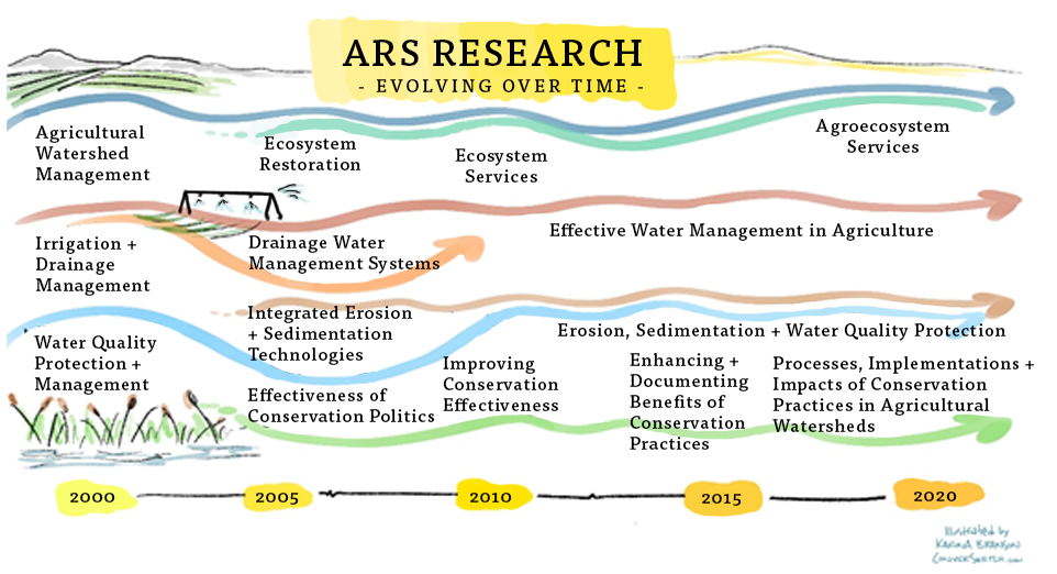
Establishment of the Office of Scientific Quality Review (OSQR) in 1999 led to the first ARS water resources research strategy, including 5-year peer-reviewed plans that have been informed by stakeholder input. Referred to as Action Plans, the components have changed somewhat from 2000 to 2020 (Fig. 5), reflecting changes in research needs. However, the overall mission has been consistent: to develop new and improved practices, technologies, and strategies for managing the Nation's agricultural water resources.
|